
Water Before the Waterway
The story of the Trent–Severn Waterway does not begin with engineers, survey chains, or federal contracts. It begins with water — and with the patient, violent work of ice over thousands of years.

Balsam Lake at sunrise — the summit of the Trent-Severn Waterway, 256 metres above sea level. Photo: RichardBH, CC-BY 2.0
During the last glacial period, retreating ice sheets sculpted the landscape of central Ontario into a labyrinth of lakes, rivers, wetlands, and rock ridges. South of what would become the waterway corridor, glaciers deposited the great drumlin fields of the Kawartha region, including the extensive Peterborough Drumlin Field. To the north, the ancient granite of the Canadian Shield rose bare and fractured above the treeline. Between these two geologies lay a natural corridor of connected water bodies stretching from the Bay of Quinte on Lake Ontario all the way to Georgian Bay on Lake Huron.
This geological inheritance determined everything that followed. The eventual waterway would not be a simple canal cut across level ground. It would be a hybrid system — part river, part natural lake, part engineered channel — forced to climb a summit at Balsam Lake before descending toward either shore. CHS CEN309 records this clearly: Balsam Lake sits at the high point of the route, 182 metres (597 feet) above Lake Ontario and 80 metres (263 feet) above Georgian Bay, making it the highest navigable point in the entire Great Lakes–St. Lawrence drainage basin.
Long before the first survey rod was planted, this landscape was already a transportation network. For thousands of years, Indigenous peoples used these connecting waters as corridors for movement, trade, and subsistence. The territory through which the Trent–Severn flows today falls within the traditional territories of the Williams Treaties First Nations, the Anishinaabeg, and the Huron–Wendat. In this sense, the Trent–Severn was not invented in the nineteenth century. It was inherited.
Indigenous Origins: Five Thousand Years at the Narrows
The most remarkable evidence of long-term human engagement with the Trent–Severn corridor lies not in any stone building or iron lock gate, but underwater — preserved in protective layers of silt at the Atherley Narrows, the channel connecting Lake Simcoe to Lake Couchiching.

Atherley Narrows — site of the 5,000-year-old Mnjikaning Fish Weirs, the oldest wooden fish weir system in eastern North America. Photo: Oaktree b, CC-BY-SA 3.0
At this constriction in the waterway, Indigenous peoples drove hundreds of wooden stakes into the lakebed to create a complex system of underwater fences. These are the Mnjikaning Fish Weirs. Carbon dating of the oldest wooden stakes has placed their construction at approximately 5,000 years ago — roughly 3300 BCE — during the Late Archaic period in North America. Parks Canada This predates the construction of the Great Pyramid at Giza. They represent the largest, best-preserved system of wooden fish weirs in eastern North America.
“The site contains the largest and best preserved wooden fish weirs known in eastern North America, in use from about 3300 B.C. until the recent past.”
— Historic Sites and Monuments Board of Canada, designation statement for Mnjikaning Fish Weirs National Historic Site
How the Weirs Worked
Stakes of eastern white cedar, sugar maple, birch, elm, and other local species were driven into the shallow lakebed in two interlocking alignments. One set caught fish migrating toward the warmer shallows of Lake Couchiching; the other intercepted fish moving toward the colder depths of Lake Simcoe. Brush woven among the stakes created funnel-like passages where fish could be speared, netted, or held alive for later harvest. The weirs were repaired seasonally for thousands of years.
The Name That Travelled South
The Huron–Wendat called this place ouentaronk; the Mohawk knew it as tkaronto, meaning “where there are trees standing in the water.” Wikipedia That name gradually transferred south along the trade route to Lake Ontario, eventually attaching itself to a fort at the lake’s north shore, and then to the city that grew around it. The modern name “Toronto” traces its linguistic roots to the fish weirs of Mnjikaning.
In 1615, Samuel de Champlain recorded the weirs in use when he passed through the narrows with a Huron war party. CHS CEN309 His route through the interior is, in its essentials, the Trent–Severn Waterway: the same lakes, the same river valleys, the same portages around falls and rapids.
The Military Vision: Surveys and Strategy (1783–1832)
The desire to engineer the Trent–Severn corridor was born not from commercial optimism, but from military anxiety. Following the American Revolution, the arrival of United Empire Loyalists transformed Upper Canada into a region with defensible interests and exposed supply lines along Lake Ontario — waterways easily threatened by American naval power in any future conflict. CHS CEN309
British military planners began surveying inland routes as a strategic alternative. The War of 1812 reinforced every argument for such a route: American forces crossed Lake Ontario and attacked York (present-day Toronto), demonstrating precisely the threat that inland canal planners had anticipated.

American naval forces at the Battle of York, 1813 — the attack that proved Upper Canada needed inland military waterways. Watercolour by Owen Staples, 1914. Public domain.
By the early 1830s, commercial pressure had joined the military case. Settlers spreading into the Kawartha region needed reliable access to markets. The provincial government of Upper Canada authorized a full survey of the route. The survey confirmed that a connected waterway was possible — but locks, dams, and dredged channels would all be necessary. In 1833, construction began.
Breaking Ground: The First Phase (1833–1860)
Construction formally commenced in 1833 under the Inland Water Commission, acting on the authority of Lieutenant–Governor Sir John Colborne of Upper Canada. CHS CEN309 The supervising engineer was Nicol Hugh Baird (1796–1849), a Scottish-trained civil engineer who had already contributed significantly to canal and road development across the Canadas.
The First Works
At Purdy’s Mill — where Lindsay stands today — a dam raised water levels in the Scugog valley by approximately three metres. In 1834, a dam at Bobcaygeon raised Sturgeon Lake by 1.5 metres. CHS CEN309 Locks were built at Glen Ross, Hastings, and Peterborough, connecting segments of the lower Trent system. Progress was real but always fragmentary — improving one reach while the next remained impassable.
Political Disruption and the 1837 Rebellions
The Rebellions of 1837 brought construction to a halt. Funds were redirected toward border security; without regular payments, contractors defaulted and work stopped. Wikipedia With the Act of Union in 1841 and the creation of a Board of Works, construction resumed — but remained incremental.
Confederation and Federal Ambition (1867–1882)
Confederation in 1867 changed the scale at which infrastructure could be imagined. The Trent–Severn, once a provincial project of uncertain future, became part of a national conversation about transportation and development.
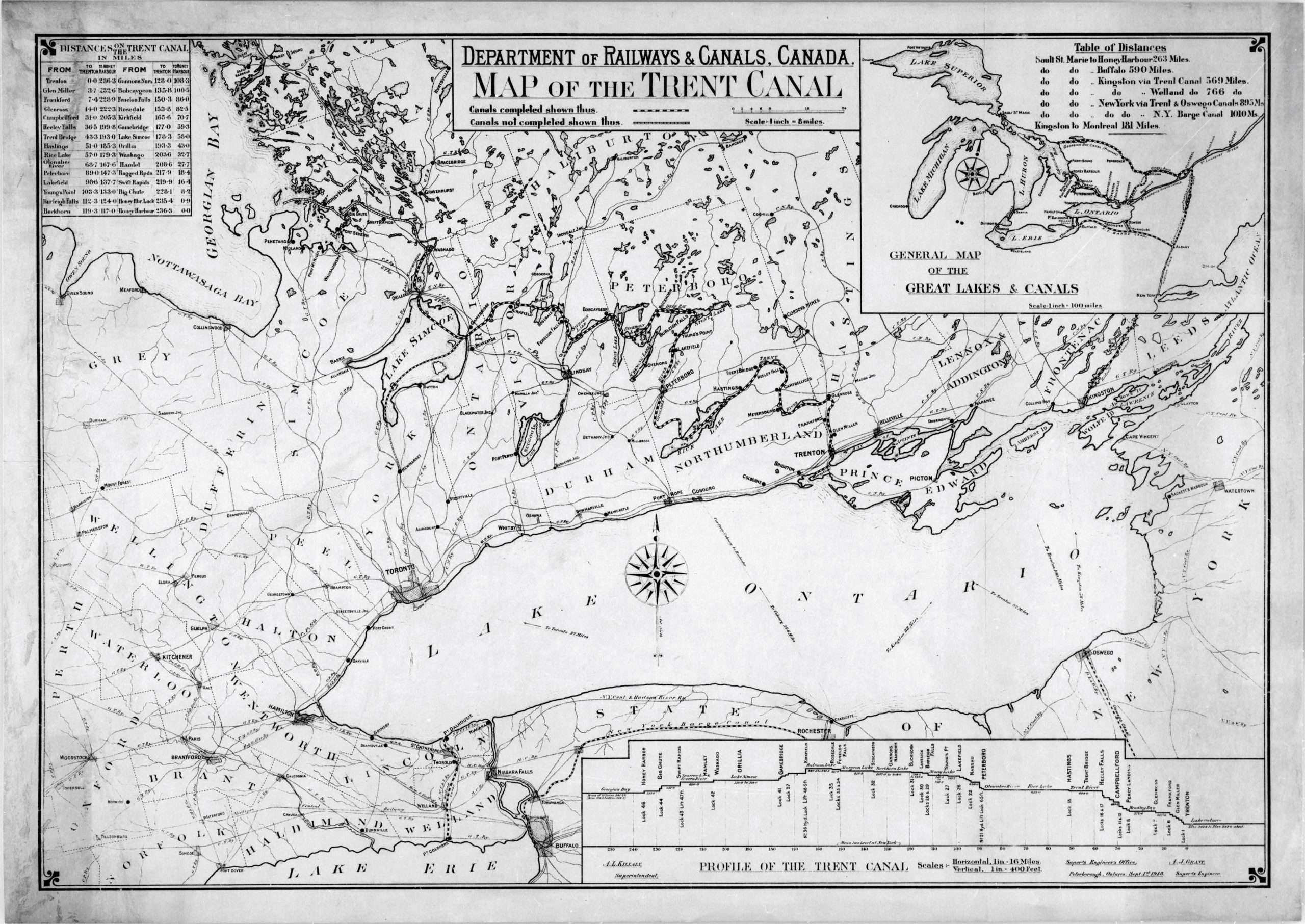
The Trent Canal system as mapped by the Department of Railways & Canals, 1918 — showing the complete route from Trenton on Lake Ontario to Port Severn on Georgian Bay, with inset illustrating the waterway’s relationship to the Rideau Canal, Welland Canal, and Erie Canal. A.L. Killaly, Public domain.
Between 1883 and 1887, the Dominion Government committed to a significant new phase: locks and short canal sections were built at Burleigh Falls, Lovesick Lake, Buckhorn, and Fenelon Falls, finally linking the Kawartha Lakes chain into a connected navigable system. CHS CEN309 A Royal Commission in 1888 recommended connecting Lake Simcoe to Rice Lake — and with that recommendation came the project’s most audacious phase, and the engineer who would define its character: Richard Birdsall Rogers.
The Great Engineering Era: Rogers and the Lift Locks (1884–1912)
Of all figures in the Trent–Severn’s history, none left a mark as deep as Richard Birdsall Rogers. Born January 15, 1857 in Peterborough, Rogers graduated from McGill College with degrees in both mechanical and civil engineering. Wikipedia In 1884 he was appointed Superintending Engineer of the Trent Valley Canal, a position he held until retirement in 1906. He inherited a fragmented system and a daunting problem: at Peterborough, the terrain imposed a 20-metre elevation change in a confined urban area.

The Peterborough Lift Lock (Lock 21), photographed in 1911 — seven years after opening as the world’s highest hydraulic lift lock. Community Archives of Belleville & Hastings County. Public domain.
The Hydraulic Lift Lock Solution
In 1896, Rogers travelled to France, Belgium, and England to study hydraulic lift locks already operating in Europe — particularly those on the Canal du Centre in Belgium. Wikipedia Two water-filled caissons on hydraulic rams would balance each other: when one descended, the other rose, with only a small addition of water needed. Rogers’ design departed from European precedent by constructing the supporting towers from concrete rather than timber or masonry — unprecedented at this scale, giving the nascent Ontario cement industry a major stimulus. Wikipedia
Construction and Opening (1896–1904)
Construction approval came in 1896, wrapped in politics: the Conservative government fast-tracked the project to shore up support before an election. Contracts were signed before working drawings were complete. The government fell anyway; the incoming Liberals did not cancel the project. On July 9, 1904, the Peterborough Lift Lock was formally inaugurated before thousands of spectators. Wikipedia At 19.8 metres (65 feet) of lift, it was the highest hydraulic lift lock in the world — a record it holds to this day.
“With a height of 19.8 metres, it is the highest hydraulic lift lock in the world. Only eight lift locks of this type have been built in the world.”
— Parks Canada interpretive marker, Peterborough Lift Lock National Historic Site
Kirkfield Lift Lock: Completing the Summit (1907)
Three years later, the Kirkfield Lift Lock (Lock 36) was completed in 1907, positioned at the height of land where waters divide between Lake Ontario and Georgian Bay. Wikipedia Built of steel rather than concrete, it has a lift of approximately 15 metres (49 feet). With its opening, over 274 kilometres (171 miles) of continuous through-route were accessible. CHS CEN309 The summit had been crossed.
Wartime Interruptions and the Final Links (1912–1920)
The final section — the Severn River division connecting Lake Couchiching to Georgian Bay — was the most difficult and the most disrupted. In June 1918, the Ontario–Rice Lake division opened, providing Lake Ontario access at Trenton for the first time. CHS CEN309 But the Georgian Bay connection remained incomplete.
Big Chute: A Wartime Solution
In 1914, contracts were awarded for conventional locks at Big Chute and Swift Rapids. Then the First World War began. Labour and material shortages stalled construction. Lock 45 at Port Severn was nearly finished and was completed as a small “temporary” lock — one still in use today. Parks Canada At Big Chute and Swift Rapids, marine railways — inclined rail tracks carrying vessels over a height of land — were built instead. The first Big Chute Marine Railway was completed in 1917.
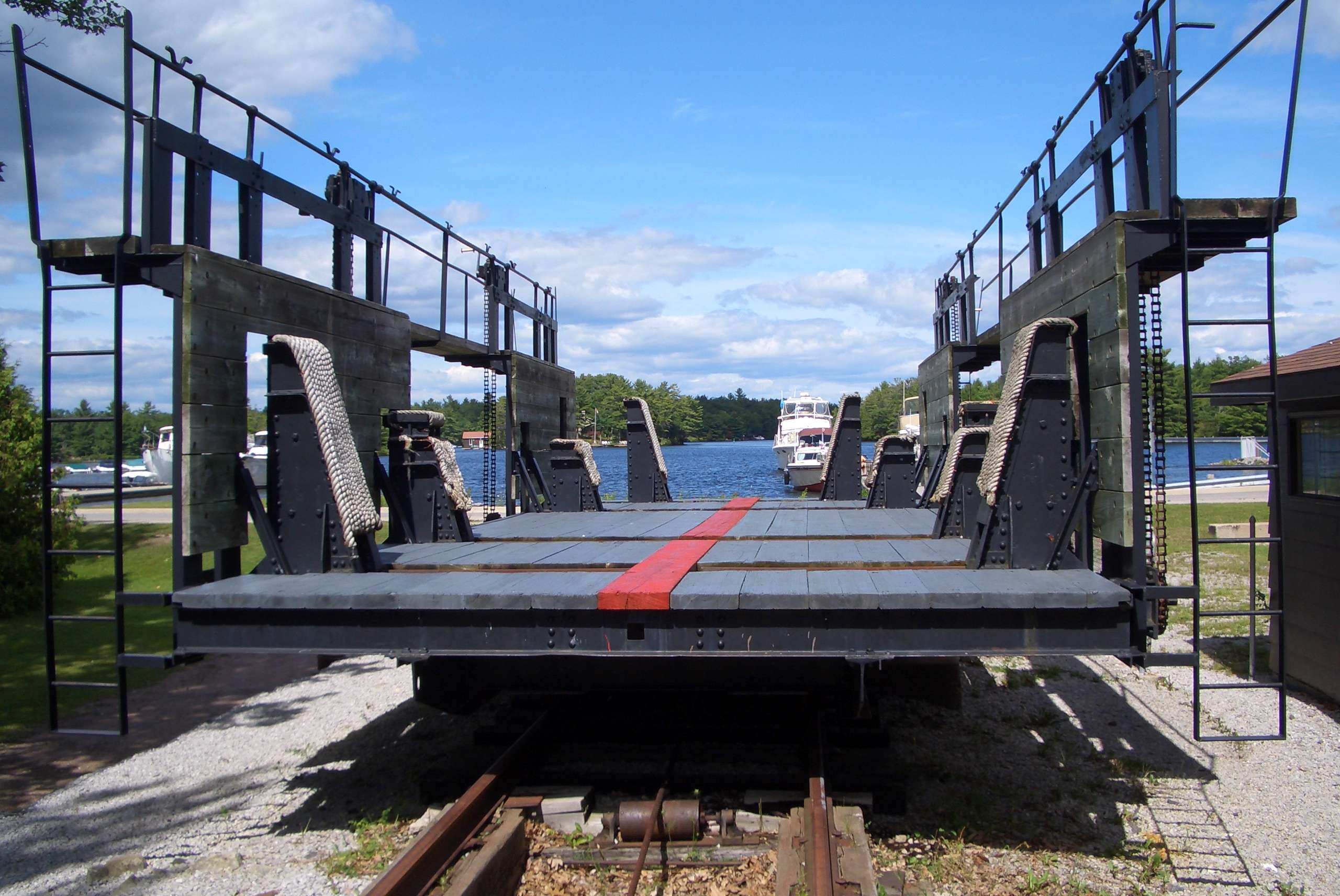
The original Big Chute Marine Railway — built in 1917 as a wartime alternative to a conventional lock, and still the only operating marine railway in North America. Photo: Motorbiker, CC-BY-SA 3.0
Wikipedia
On July 6, 1920, the Couchiching Lock near Washago was opened, providing navigation to Georgian Bay for vessels up to 2.7 m (9 ft) beam and 11 m (36 ft) length. CHS CEN309 The through-route was complete.
The First Through-Trip: Motor Launch Irene, July 1920
On July 3, 1920, a small motor launch named Irene departed from Trenton, Ontario. Nine days later, on July 12, she arrived at Port Severn on Georgian Bay. CHS CEN309 The Irene was the first vessel to complete a continuous through-transit of the Trent–Severn Waterway — covering 386 kilometres through more than forty lock chambers, marine railways, swing bridges, and open lake crossings.
“The first vessel to make this through trip was the motor launch Irene which left Trenton on July 3, 1920 and arrived at Port Severn on July 12, 1920.”
— Canadian Hydrographic Service, Sailing Directions CEN309 (2025 edition)
The irony of the Irene’s voyage was already visible. Built to carry commerce, the waterway arrived too late for that purpose. The motor launch that completed the inaugural through-trip was not a cargo vessel — it was a pleasure boat. The future of the waterway was written into the character of that first crossing.
Heritage Recognition and the Modern Waterway
In 1929, the Historic Sites and Monuments Board of Canada formally recognized the Trent–Severn Waterway as nationally significant — the beginning of its formal identity as a heritage site. Parks Canada The waterway was designated because it represented the integrated development of Canada’s national canal system, embodied in its engineering structures, lock chambers, dams, bridges, and the cultural landscapes created around them.
Today the Trent–Severn is Canada’s second-largest national historic site. Parks Canada It encompasses over 4,500 kilometres of shoreline, more than 500 square kilometres of water surface, and approximately 800 built assets valued at over $5 billion.
The Canal That Became a Corridor
The commercial objectives that justified eight decades of construction were never achieved. The final sections opened too late, the locks were too small for industrial-era shipping, and the railways had already won. But the same dimensions that made the waterway commercially marginal made it perfectly suited for recreational boating. The motorboat explosion of the 1950s and 1960s transformed the Trent–Severn from a failing canal into one of Ontario’s defining recreational destinations — a slow-travel corridor through cottage country, a passage through history.
The Great Loop Connection
The Trent–Severn forms a major segment of America’s Great Loop — the circumnavigation of eastern North America by inland and coastal waterways. Thousands of Great Loopers transit the waterway each year, connecting via Lake Ontario and the Erie Canal to the entire eastern seaboard of North America.
Two of only eight hydraulic lift locks ever built in the world remain in daily operation here — monuments to the engineering ambition of the 1890s, still lifting boats by the same mechanism that Richard Birdsall Rogers designed more than 125 years ago.

Recreational boats in the Peterborough Lift Lock — Rogers’ 1904 engineering marvel, still in daily service more than a century later. Photo: Ron Crough, CC-BY-SA 3.0
🕑 Construction Timeline
World and Canadian Engineering Firsts on the Trent–Severn
The Trent–Severn’s construction record is remarkable not simply for its scale, but for the engineering innovations it pioneered.
Waterway Facts at a Glance
| Total length | 386 km (241 mi) CHS CEN309 |
| Man-made channel | 32 km (20 mi) CHS CEN309 |
| Number of locks | 44 (incl. 2 hydraulic lift locks and 1 marine railway) Parks Canada |
| Summit — Balsam Lake | 256.3 m (841 ft) ASL; 182 m (597 ft) above Lake Ontario; 80 m (263 ft) above Georgian Bay CHS CEN309 |
| Construction period | 1833–1920 (final development to 1930) Parks Canada |
| NHS designation | 1929 Parks Canada |
| Administering agency | Parks Canada, Environment and Climate Change Canada Parks Canada |
| First through-transit | Motor launch Irene, July 3–12, 1920 CHS CEN309 |
| Navigation season | Mid-May to mid-October CHS CEN309 |
| Dams and control structures | ~160 Parks Canada |
Continue Exploring the Trent–Severn
The history comes alive lock by lock. Each lockstation has its own story.