About This Guide
Captain Dustin’s Guide to the Trent‑Severn Waterway is an independent, lock-by-lock marine intelligence resource built for recreational boaters and Great Loop cruisers navigating Ontario’s historic 386-kilometre inland passage.
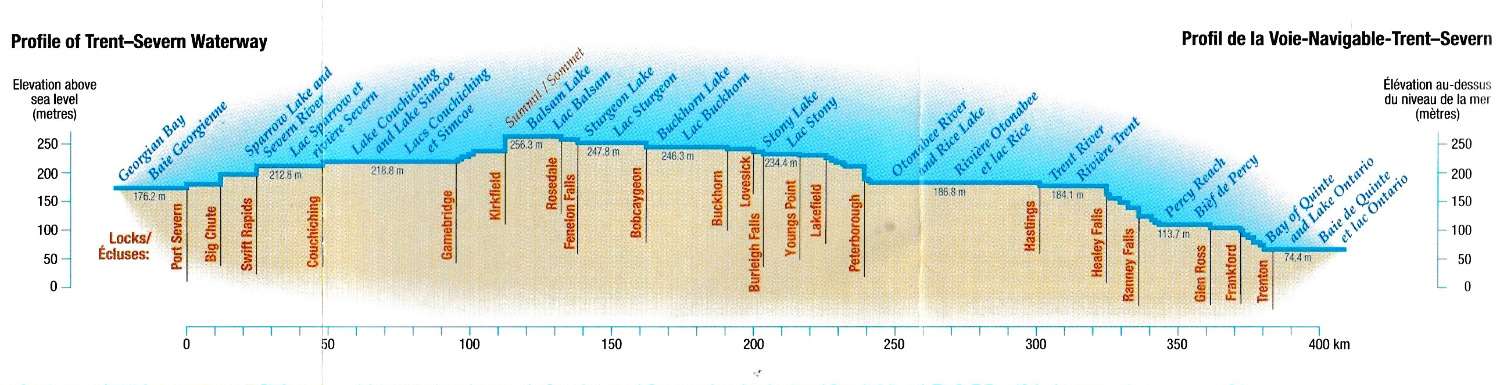
This guide covers all 44 locks spanning 208 nautical miles from Trenton on the Bay of Quinte to Port Severn on Georgian Bay — including lock details, approach notes, anchorage assessments, marina listings, and practical cruising intelligence researched from the helm.
Why This Guide Exists
Official charts and publications are essential for safe navigation, but they don’t always answer the practical questions a cruiser has when planning a day’s run on the Trent‑Severn: Where can I anchor tonight? What’s the approach like at the next lock? Is there fuel within reach?
This guide fills that gap — combining official data from Parks Canada, the Canadian Hydrographic Service, and Notices to Mariners with on-the-water observations and cruiser reports to create a single, practical reference for the entire waterway.
Running this guide is not free. Hosting, domain registration, chart data subscriptions, AI tools for research and content maintenance, and the software behind the maps and directories all cost real money — and it adds up. There are no ads here, no sponsor deals, and no paywall. If this guide has helped you plan a passage or find a good anchorage, consider chipping in: buy the skipper a coffee ($5), a beer ($10), or dinner ($25). Every contribution helps keep the lights on and the data current.
What You’ll Find Here
- Lock Pages — Detailed profiles for all 44 locks with approach notes, GPS coordinates, lift heights, operating hours, and navigation charts.
- Anchorage Directory — 60+ assessed anchorages with depth data, bottom type, holding quality, wind protection ratings, and skipper notes.
- Marina Directory — Marina listings along the waterway with services, contact information, and location maps.
- History — The story of the Trent‑Severn Waterway from its First Nations origins through the canal-building era to the present day.
Our Sources
Every page on this site draws from authoritative sources, cited where applicable:
- Parks Canada — Official lock information, regulations, seasonal operating dates
- Canadian Hydrographic Service (CHS) — Sailing Directions CEN309, official chart data
- Waterway Guide / Wavve Boating — Depth soundings, anchorage assessments, chart imagery
- Transport Canada / Notices to Mariners — Navigation safety notices and regulatory updates
- Cruiser reports — On-the-water observations from boaters who have transited the system
About Captain Dustin
Dustin Norlund has spent more than 30 years on the water. He holds a United States Coast Guard 50-Ton Master license and a Transport Canada SVOP captain’s certificate, and has logged roughly 47,000 nautical miles — multiple Atlantic crossings to the Caribbean, two Panama Canal transits, Pacific Ocean passages, the U.S. east coast and Intracoastal Waterway, the Great Lakes, and the canal systems that connect them. He has owned and run boats ranging from a 19-foot catamaran to motoryachts in the 60-foot range, and lives along the Trent‑Severn.

His marine credentials run deeper than the master tickets. He is an accredited marine surveyor through both SAMS and IIMS, an ABYC Standards Advisor, and a certified sailing instructor, holding American Sailing Association instructor ratings in keelboat, coastal cruising, bareboat, and coastal navigation. He carries a Restricted Operator Certificate (Maritime) for VHF, a Canadian Pleasure Craft Operator Card, and current CPR and marine first aid certification. Surveying boats for a living means he looks at a hull, a chart, or an anchorage the way an inspector does — what’s actually there, not what the brochure says.
He has transited the full Trent‑Severn Waterway four times and the Welland Canal three times, in vessels from 45 to 62 feet. The runs include a 400-mile delivery from Lake Ontario through all 44 locks to Lake Huron, and most recently a 2,600-mile run from Daytona Beach, Florida — up the Intracoastal, through the Erie and Oswego canals, across Lake Ontario, and home through the Trent‑Severn. He has locked through the Peterborough hydraulic lift and ridden the Big Chute marine railway enough times to have opinions about both.
This guide exists because the information was always out there — it was just scattered and hard to use. Lock details, anchorage notes, and depth figures were spread across forum threads, decades-old guidebooks, and PDFs that hadn’t been updated in years. Parks Canada’s official material gives you lock hours; the tourism sites tell you it’s scenic. Neither pulls together where the water actually shallows, which lock walls have power, where the holding is poor, or which anchorages are exposed to a north wind. Drawing on established resources, AI tools, and his own time on the waterway, Dustin built this guide to bring that picture into one place — lock by lock and anchorage by anchorage, with depths, holding, and protection collected in one current, consistent format.
It is free, and it always will be. It does not replace your charts or Parks Canada’s official notices to mariners — check those first, every time. It is meant to sit alongside them: the local knowledge a dock neighbour would give you if you happened to tie up next to one who had done the run a few times.
Support This Guide
Captain Dustin’s Guide is a one-person operation. There’s no ad revenue, no sponsor deals, no paywall. Hosting, chart subscriptions, research tools, and the time it takes to keep 60+ anchorages and 44 locks current all come out of pocket. If this guide saved you time on the water or helped you find a great anchorage, a small contribution goes a long way toward keeping it running.
☆ Buy the Skipper a CoffeeUse of Artificial Intelligence
This site uses artificial intelligence tools in the creation, editing, and maintenance of its content. While we review AI-assisted output for accuracy, AI can make mistakes. All information — whether written by a human, assisted by AI, or compiled from third-party sources — should be independently verified before being relied upon for navigation or safety decisions. See our Terms of Use for full details.
Important Disclaimer
This is not an official Parks Canada publication. trentsevernguide.com is an independent boater reference. Navigation data presented here is for general information only and must not be used as a substitute for official nautical charts, Notices to Mariners, or proper navigational judgment. The skipper of any vessel is solely responsible for all navigation decisions.
Always carry and consult current CHS charts and publications before making navigation decisions on the Trent‑Severn Waterway.
Contact
Found an error? Have a suggestion? We welcome corrections and contributions from fellow boaters.
trentsevernguide.com is an independent boater reference for the Trent–Severn Waterway. It is not an official publication of Parks Canada, the Canadian Hydrographic Service, or any government body.